Hit enter to search or ESC to close
Nós
Organización
Directorio de persoal
Padroado
Contacto
Novidades
Eventos
Novidades
Proxectos
Publicacións
Memoria
Centro de documentación
Boletín de novas
Contratación
Ofertas de traballo
Licitacións
Transparencia e goberno aberto
Search
Más populares
Economía azul
9 Novembro, 2022
Padroado CETMAR
18 Decembro, 2024
Intercambio de coñecementos
2 Decembro, 2024
Últimas noticias
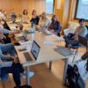
Reunión do padroado
30 Xuño, 2025
Contaminación mariña e terrestre
4 Xuño, 2025
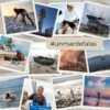
#UnMarDeFalas
3 Xuño, 2025
Ciencia e mar
29 Maio, 2025
Nós
Organización
Directorio de persoal
Padroado
Contacto
Novidades
Eventos
Novidades
Proxectos
Publicacións
Memoria
Centro de documentación
Boletín de novas
Contratación
Ofertas de traballo
Licitacións
Transparencia e goberno aberto
Utilizamos cookies para asegurar que damos la mejor experiencia al usuario en nuestra web. Si sigues utilizando este sitio asumiremos que estás de acuerdo.
Vale
Política de privacidad